info dump, copy and paste, notes to self.
OLD MELBOURNE GAOL Russell Street
NORTH 6
Photographer W R Garrett
1924 aerial view of Old Melbourne Gaol from State Library of Victoria Picture Collection:
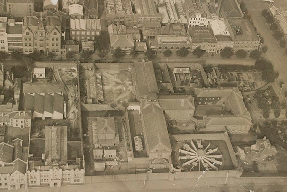
note: slv dates this photos as 1920s. Peter Andrew Barrett on a FB post dates it as 1924 taken immediately before it’s closure.
LEFT TO RIGHT:
Cnr of La Trobe and Russell St is former Magistrates Court just in frame.
Old City Watch House is shouldered between Magistrates Court and gaol complex including male hospital building and gallows door.
To the right is visually distinctive Panopticon exercise yard with watchouses on either side. To extreme right is the Prison Governor’s residence.
Main entrance of prison is facing north into Victoria St.
Jail complex bordered by Bowen St as treelined street running north to south in photo.
Current site:
In 1926 Emily McPherson College of ‘Domestic Economy’ built on site of Governor’s residence [and partial site of panoptican]. Now part of RMIT campus.
Main entrance of prison is obscured and tourist entrance to remaining sections of gaol still standing is now from Russell St via the former recess room for the guards. [source: Old Melbourne Gaol walking tour pamphlet]
Bowen St becomes part of RMIT campus.
also:
‘Part of the gaol wall in Russell Street was also retained, and for many years it formed part of the Victoria Police garage. The wall now forms a courtyard on the RMIT campus. Other parts of the gaol that remain are the east wing of the cell block; and the former entrance to the gaol in Franklin Street, with its finely-detailed archway’.
[SOURCE from facebook post: by Peter Andrew Barrett – Architectural and Urban Historian, Writer & Curator]
REUSED BLUESTONE:
‘Bluestone removed from the site in the demolition of the gaol, was used by the Melbourne Harbor Trust for their works to the port. Bluestone removed was also used on other public works’.
[SOURCE from facebook post: Text by Peter Andrew Barrett – Architectural and Urban Historian, Writer & Curator from FB post]
FORMER OLD MELBOURNE GAOL BURIAL MARKERS:
-The bluestone wall near the prison graveyard was engraved with around 30 executed prisoner’s initials and dates of execution.
-When the prison closed, graves were dug up and bodies relocated to Pentridge, some successfully identified.
-Some of this bluestone was repurposed for creation of seawall in Brighton as part of public works in 1920s-30s
‘[Bluestone] blocks were carted down to Brighton to be used in the seawall, including those carefully chiselled grave markers.
To this day, that’s where many of the grave markers remain — slotted neatly into a wall stretching several kilometres along prime beachfront, either facing a daily battering by waves and weather or buried under encroaching sand.’
SOURCE :
‘Relics of Victoria’s criminal history are being buried in sand at Melbourne’s Brighton Beach’
By Tim Callanan ABC news Posted Thu 9 Jan 2020
https://www.abc.net.au/news/2020-01-09/relics-of-victorian-criminal-history-undergoing-sandy-burial/11793906
and this:
‘The Brighton Beach sea wall contains the largest number (six) of known former Old Melbourne Gaol bluestone burial markers. It is likely that other markers exist in the sea wall between Brighton and Beaumaris. The bluestone blocks at Brighton Beach foreshore contain the initials of six executed inmates including: Philipi Castillo (executed 16.9.1889); John Wilson (23.3.1891); Joseph Pfeffer (29.4.1912); John Conder (28.3.1893); Fatta Chand (27.4.1891) and William Colston (24.8.1891).
The sea wall along the Brighton Beach foreshore was constructed as part of a public works initiative established to address unemployment’.
Victorian Heritage Database
FORMER OLD MELBOURNE GAOL BURIAL MARKERS
https://vhd.heritagecouncil.vic.gov.au/places/104594
TIMELINE::::
built between 1841 and 1844 at the corner of Russell and La Trobe Streets, adjoining the then Supreme Court.[3] The first cell block was opened for prisoners in 1845, but the facilities were considered inadequate; escapes occurring frequently. The gaol was already crowded by 1850.[4]
With the discovery of gold in 1851 (when the Port Phillip District became the new Colony of Victoria), and the resulting influx of population, law and order became more difficult to maintain. Subsequently, a new wing, with its own perimeter wall, was constructed between 1852 and 1854; the building using bluestone instead of sandstone. The design was based on that of British prison engineer Joshua Jebb, and especially the designs for the Pentonville Model Prison in London (which suited the current prison reform theories at the time). The new wing was extended in between 1857 and 1859, with the boundary wall also being extended during this time. In 1860, a new north wing was built; which included entrance buildings, a central hall and chapel. Between 1862 and 1864, a cell block was built for female prisoners on the western side – it was basically a replica of the present east block (until this time, female convicts were not kept apart from the male prisoners).[5] In 1864, the perimeter wall, and the gaol overall, was completed;[3][6] making it a dominant feature of authority on the Melbourne skyline.[3]
At its completion, the prison occupied an entire city block, and included exercise yards, a hospital in one of the yards, a chapel, a bath house and staff accommodation.[4] A house for the chief warders was built on the corner of Franklin and Russell streets, and 17 homes were built for gaolers on Swanston Street in 1860.[3] Artefacts recovered from the area indicate that even the gaolers and their families lived within the gaol walls in the 1850s and 1860s.[7]
-SOURCE https://en.wikipedia.org/wiki/Old_Melbourne_Gaol#:~:text=An%20allotment%20of%20scrubland%20to,colloquially%20known%20as%20Wintle’s%20Hotel.
