in chronological order
Robert Russell map of Melb with grid and showing nothing for fitz area
circa 1837
Map shewing the site of Melbourne and the position of the huts & buildings previous to the foundation of the township by Sir Richard Bourke in 1837 [cartographic material] / surveyed & drawn by Robert Russell.
Russell, Robert, 1808-1900.
SLV COPY:
https://handle.slv.vic.gov.au/10381/170516
CONTEXT: ‘Hoddle and his assistant Robert Russell prepared the plan that laid the foundation for Melbourne, with Hoddle placing his plan over the original survey drawn by Russell’.
SOURCE p11 Context Pty Ltd 2012, Thematic History: A History of the City of Melbourne’s Urban Environment, prepared for the City of Melbourne.
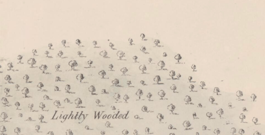
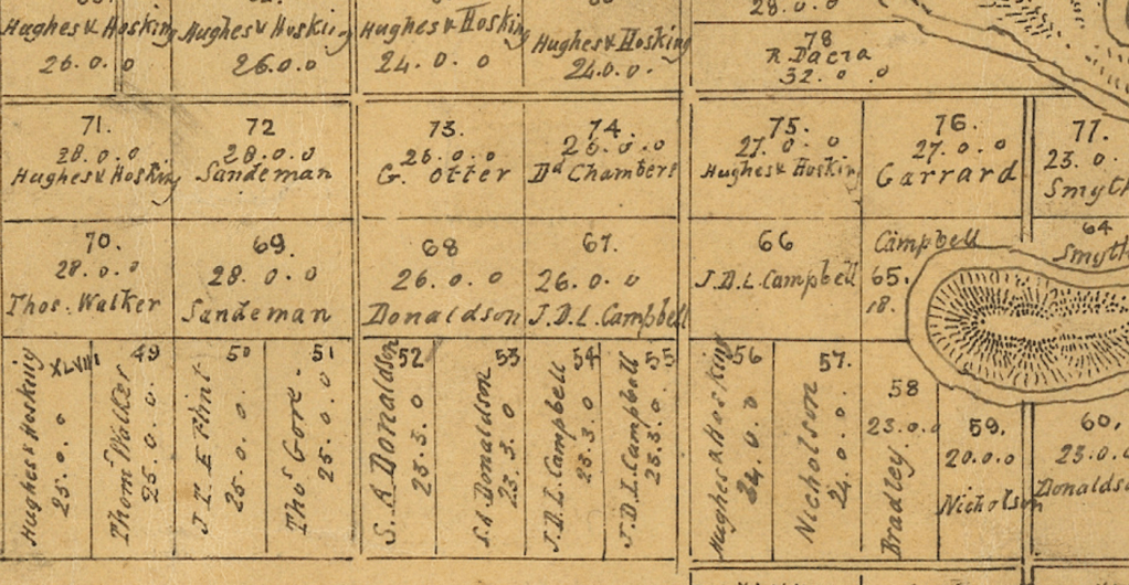
Plan of the Parish of Jika Jika in the County of Bourke.
Date map created: unknown [between 1837 and 1850?]
Date I give to this map: not before xxx and not contemporary after xxx
Anon (1837) Plan of the Parish of Jika Jika in the County of Bourke.
great because: has the government allotments and the first purchasers listed against each allotment
thumbnail:
https://handle.slv.vic.gov.au/10381/262194
cite: Anon (1837) Plan of the Parish of Jika Jika in the County of Bourke.
////////////////////
c1851-54
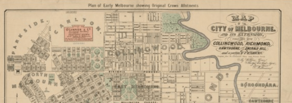
Plan of the city of Melbourne also shewing North Melbourne, Carlton, East Melbourne, & Collingwood [cartographic material]./ published by Campbell & Ferguson ; lithogr. by A. Robertson.
https://handle.slv.vic.gov.au/10381/161532
//////////////////
1852
1852 HODGKINSON SURVEY
I’ve since learned the original is at public records office:
permanent link: https://prov.vic.gov.au/archive/FDB74EAA-F858-11E9-AE98-83693D179613?image=1
MELBRL3
COLLINGWOOD AND EAST MELBOURNE CONTOURED PLAN; HODGKINSON;; JIKA JIKA MELBOURNE NORTH
CITATION: VPRS 8168/P0002, MELBRL3
dated: 1852-01-01 – 1852-12-31]
context:These plans…were intended to show all buildings. The first survey was commissioned late in 1852 by a select committee of the Legislative Council, which was inquiring into water supply and sewerage for Melbourne.
source: p24- The Inner Suburbs: The Evolution of an Industrial Area by Bernard Barrett, Melbourne University Press, 1971
1852 repo
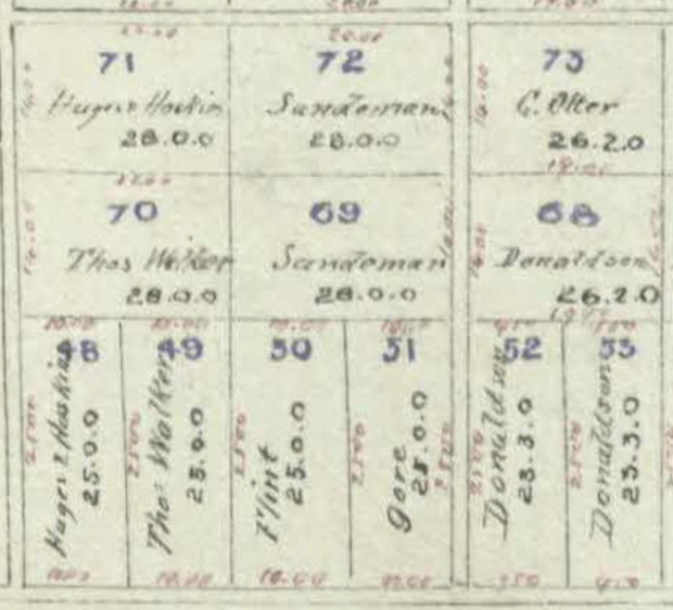
The Green, W. & James O’Connor & Co map of Melbourne.
Date the map represents: Dec 1852 gov land divisions with overlay of streets
Date the map was published: This 1901 duplicate by William GREEEN of:
O’CONNOR land Agents map cDEC 1852 map of Melbourne inc. Fitzroy.
great because: overlays the crown land purchases against (1901?) streets
Green, W. & James O’Connor & Co. (1901) Map of the city of Melbourne and its extension [cartographic material] : together with Collingwood, Richmond, Hawthorne, the Emerald Hill, and a portion of Prahran / compiled from the government plans and private survey by William Green.
see online here: https://handle.slv.vic.gov.au/10381/114752
more info thats been researched about this map:
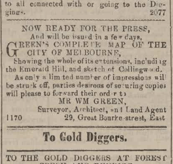
A map issued by O’Connor & Co., Land Agents. It is a copy of the original map drawn by William Green, surveyor, architect and land agent, in 1852 and released in December that year. The map covers the City of Melbourne and inner suburbs. It probably dates from the 1920s as by the 1930s PJ O’Connor had begun practising as an architect…An advertisement in the Argus of 9 December 1852 shows that the original map was available for purchase.
source: ‘East Melbourne Historical Society: 1852 Map of the City of Melbourne and its Extension – William Green Subjects: Early East Melbourne view online here:https://emhs.org.au/catalogue/emdf0402
and here’s the original Argus ad:
Advertising (1852, December 9). The Argus (Melbourne, Vic. : 1848 – 1957), p. 3. Retrieved January 9, 2026, from http://nla.gov.au/nla.news-article255612842
/////
1855
PUBS
souce for map: Brown, J. D. et al. (1855) Melbourne and its suburbs [cartographic material] / compiled by James Kearney, draughtsman ; engraved by David Tulloch and James D. Brown. Viewed online here https://find.slv.vic.gov.au/permalink/61SLV_INST/1sev8ar/alma997869963607636.
1856
Jika Jika [cartographic material] / G.A.W.
Author / CreatorVictoria. Surveyor General’s Office.
great because: definitely dated, cross references earlier map but this one is dated, shows topographical features, shows quarries and shows purchaser names from original allotment sales.
https://handle.slv.vic.gov.au/10381/170391
source: Woods, G. A. (1856) Jika Jika [cartographic material] / G.A.W. online here: https://handle.slv.vic.gov.au/10381/170391
SUBDIVISION MAP WHAT DATE?
source: Anon (1837) Plan of subdivision of suburban portion no. 51 situate at Collingwood in the Parish of Jika Jika in the County of Bourke. Viewed online here https://find.slv.vic.gov.au/permalink/61SLV_INST/1sev8ar/alma9925478733607636
1899
more on Board of Works map: source:
Anon (1899) Melbourne and Metropolitan Board of Works detail plan. no. 1202, City of Fitzroy [cartographic material]. See online here: https://find.slv.vic.gov.au/permalink/61SLV_INST/1sev8ar/alma9911645233607636
