| THE YARRA RIVER Etymology: version one: Yarro Yarro The actual name of the Yarra River is Yarro-yarro, which is a Wurundjeri term in the Boonwurrung language meaning “ever-flowing.” This is a very accurate description as the river is a perennial waterway, meaning it has a continuous flow all year round due to years of normal rainfall. -SOURCE Six Things You Didn’t Know About The Yarra River-https://oceanprotect.com.au/news_post/six-things-you-didnt-know-about-the-yarra-river/ version two: Birrarung (recognised by City of Melbourne) Prior to European settlement the Yarra River, or Birrarung, as it was known by the Wurundjeri, was a ‘river of mists and shadows’ (Annear, 2005:xi). SOURCE Melbourne’s Hidden Waterways: Revealing Williams Creek by Janet McGaw and Cliff Chang, University of Melbournehttps://doubledialogues.com/article/melbournes-hidden-waterways-revealing-williams-creek/ and The Falls was a natural basalt ridge that ran across the Birrarung (Yarra River), dividing the river into two different ecosystems: freshwater above and saltwater below. source: The Falls Birrarung (Yarra River) https://aboriginal-map.melbourne.vic.gov.au/85 Pre European Settlement Appearance: A clear fresh water river up to the Falls. deep basin before The Falls: – Enterprize Park was formerly a deep basin carved out of the river bank by thousands of years of pounding by Freshwater Falls. It is now covered by a deck.SOURCE Melbourne’s Hidden Waterways: Revealing Williams Creek by Janet McGaw and Cliff Chang, University of Melbournehttps://doubledialogues.com/article/melbournes-hidden-waterways-revealing-williams-creek/ Muddy quality: At some point in 1800s (documented? observed? examples?) high levels of land clearing and development cause ‘microscopic clay particles’ from surrounding clay soils ‘enter the river’ creating the brown opaque water colour. ‘The strong brown, muddy colour of the river is caused by clay soils. The clay soil in the region breaks up into tiny particles and dissipates throughout the whole of the river…high levels of land clearing and development caused these microscopic clay particles to enter the water, making it the colour it is today.’ -SOURCE Six Things You Didn’t Know About The Yarra River-https://oceanprotect.com.au/news_post/six-things-you-didnt-know-about-the-yarra-river/ Late 1800s Pollution: Despite the enormous population boom once gold was discovered, no sewerage collection or treatment system was constructed until 1898. The Yarra was described in the late 1800s as the ‘filthiest piece of water I have ever had the misfortune to be afloat on’, and Melbourne earned the nickname of ‘Marvellous Smellbourne’( Lewis, 1995: 68). SOURCE Melbourne’s Hidden Waterways: Revealing Williams Creek by Janet McGaw and Cliff Chang, University of Melbourne https://doubledialogues.com/article/melbournes-hidden-waterways-revealing-williams-creek/ Late 1800s: Esturarine Salty waters mix with freshwater with dynamiting of The Falls Freshwater Falls had by this point become problematic, preventing access upstream to the spreading township. They were destroyed with dynamite. While at the time, given the state of the Yarra it may not have seemed detrimental to add salt [[ie the bay’s esturaine salty waters]]to the mix of pollution; it has ecological consequences to this day, long after much of the pollution by industry has been cleaned up. SOURCE Melbourne’s Hidden Waterways: Revealing Williams Creek by Janet McGaw and Cliff Chang, University of Melbourne https://doubledialogues.com/article/melbournes-hidden-waterways-revealing-williams-creek/ |
| THE FALLS : natural bluestone reef barrier and rapids/small waterfall(s) -natural bluestone reef barrier, 1 m high, SOURCE Melbourne’s Hidden Waterways: Revealing Williams Creek by Janet McGaw and Cliff Chang, University of Melbournehttps://doubledialogues.com/article/melbournes-hidden-waterways-revealing-williams-creek/ that separates tidal movement from bay SOURCE Melbourne’s Bluestone Story 2021-07-18 by Fiona Anderson https://www.weekendnotes.com/melbourne-bluestone-story/#:~:text=As%20it%20is%20an%20igneous,other%20more%20bland%2C%20greyish%20basalts and salty esturaine waters SOURCE Melbourne’s Hidden Waterways: Revealing Williams Creek by Janet McGaw and Cliff Chang, University of Melbournehttps://doubledialogues.com/article/melbournes-hidden-waterways-revealing-williams-creek/ from the freshwater river -the bluestone reef creates a natural pedestrian pathway to cross the river SOURCE Melbourne’s Bluestone Story 2021-07-18 by Fiona Anderson https://www.weekendnotes.com/melbourne-bluestone-story/#:~:text=As%20it%20is%20an%20igneous,other%20more%20bland%2C%20greyish%20basalts -The falls stops the Enterprize from further sailing up the Yarra: that the bluestone determined the settlement of Melbourne: ‘In fact, the reason Melbourne is located where it is, on the northern banks of the Yarra River, is because of bluestone. John Pascoe Fawkner’s schooner Enterprize, captained by John Lancey, sailed up the Yarra in 1835. They picked the landing site, roughly under what is now known as Queens Bridge, because there was a small waterfall, or rapids, that stopped further progress up the river. The waterfall also separated the tidal movement from freshwater. The rocks that created that natural barrier were in fact a reef of bluestone. Robert Russell’s historic sketch Melbourne From the Falls, dated 1837, depicts the landing place of the Enterprize, and shows the bluestone reef. At that time, people could walk across the outcrop from one side of the river to the other. SOURCE Melbourne’s Bluestone Story 2021-07-18 by Fiona Anderson https://www.weekendnotes.com /melbourne-bluestone-story/#:~:text=As%20it %20is%20an%20 igneous,other%20more%20bland%2C%20greyish%20basalts |
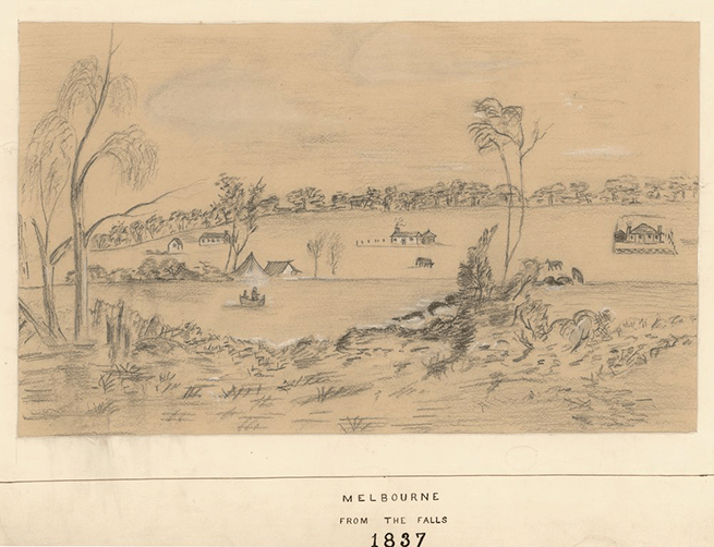
Robert Russell’s historic sketch Melbourne From the Falls, dated 1837, depicts the landing place of the Enterprize, and shows the bluestone reef.
SOURCE Melbourne’s Bluestone Story 2021-07-18 by Fiona Anderson https://www.weekendnotes.com
/melbourne-bluestone-story/#:~:text=As%20it
%20is%20an%20
igneous,other%20more%20bland%2C%20greyish%20basalts
| THE FALLS BLOWN UP BY DYNAMITE Late 1800s: Esturarine Salty waters mix with freshwater with dynamiting of The FallsFreshwater Falls had by this point become problematic, preventing access upstream to the spreading township. They were destroyed with dynamite. [[date?]]While at the time, given the state of the Yarra it may not have seemed detrimental to add salt [[ie the bay’s esturaine salty waters]]to the mix of pollution; it has ecological consequences to this day, long after much of the pollution by industry has been cleaned up. SOURCE Melbourne’s Hidden Waterways: Revealing Williams Creek by Janet McGaw and Cliff Chang, University of Melbourne https://doubledialogues.com/article/melbournes-hidden-waterways-revealing-williams-creek/ |
more info in this article so keep getting stuff from it.
VICTORIA AS A STATE
BLUESTONE HISTORY
The expansive basalt plain in Victoria, Australia spreads westward from the state’s capital city of Melbourne and is notably one of the most extensive in the world. This south-western region of Victoria was home to more than 400 volcanoes which formed this plain from 4.5 million years ago. The gold-shaded area on the map below indicates its breadth.

SOURCE Victoria’s Volcanic Plain September 20, 2011 by blessedbluestone https://blessedbluestone.wordpress.com/2011/09/20/victorias-volcanic-plain/
//////////
| ELIZABETH STREET AS VALLEY / WILLIAMS CREEK / LAKE CASHMORE |
One of Melbourne’s key north-south streets, Elizabeth Street, which followed the folds of a valley, regularly flooded, creating inconvenience to early settlers. As time has passed, this seasonal tributary has been progressively buried deeper underground to create a stable, dry surface. Emily Potter argues that there is an ‘ever-widening gulf between … our place myths – and what is environmentally and socially sustainable.’(Potter, 2007: 249). In searching for ‘firm ground’ (literally and figuratively) we deny the essential instability of our occupation of this land (Potter: 249).
…Buried below Melbourne’s Elizabeth St lies a body of water known by many names – at one time, William’s Creek. Today it is the city’s main stormwater drain – completely hidden from the public
… Lake Cashmore, a lake that once existed near the junction of Elizabeth and Collins Streets.
SOURCE Melbourne’s Hidden Waterways: Revealing Williams Creek by Janet McGaw and Cliff Chang, University of Melbourne
https://doubledialogues.com/article/melbournes-hidden-waterways-revealing-williams-creek/
—-for more details on williams river see a-z
1836
RUSSEL plays around with model colonial town layout sourced from sydney
The street plan which became known as the Hoddle Grid was initially drawn up by the surveyor,
architect and artist Robert Russel while delayed at Melbourne in 1836.
“While waiting, it occurred to me that we might as well fill in time by making a survey of the future
settlement … Out of mischief I made a survey of the site of Melbourne, without official instructions.”
(Maxwell, 2003)
The plan was not original and followed an officially developed model of how a colonial town should
be laid out. As Russell admitted, it was based on –
“… a plan in the Sydney office generally approved as suitable for laying out a new township, and I had
a copy of it… [it was] scarcely a design, simply 24 ten acre squares’.” (Maxwell, 2003)
-SOURCE p3 Elizabeth Street
Historical Character Study, Green Heritage Compliance and Research pdf
MAR 1837
Continuing Russell’s unofficial work, Governor Bourke and surveyor Robert Hoddle traced out on
horseback the streets of the new township of Melbourne in March 1837 to a design that would bear
the second surveyor’s name. Bourke named the streets, honouring his dead wife Elizabeth Jane
Bourke with Elizabeth Street, which was to become the spine of the city in the nineteenth century and
the central east west dividing axis.
Governor Bourke wrote in his journal on the 4th March 1837;
“In the afternoon rode over the ground adjacent to the huts with surveyor Hoddle and traced the
parcel outline of a township upon a beautiful and convenient site. It does not however promise to
afford water, which must be procured / at first at least / certainly from the river. A good dam will
require to be constructed here to keep up the fresh water and effect is continued separation from the
salt. There appears to be good brick earth here and stone is to be found tho’ not of a good quality for
building. Timber is to be had but at a distance of about 8 miles. Limestone is said to be found near
Point Nepean at the entrance of Port Phillip. It is […] probable that both lime and timber will for some
time be imported from Van Diemen’s Land. Tho this site is deficient in many of the important qualities
for the easy establishing of a town, it possesses the advantages of being at the head of the navigation
of a […] river”
-SOURCE p3 Elizabeth Street
Historical Character Study, Green Heritage Compliance and Research pdf
Sir Richard Bourke’s first visit to the site of Melbourne was made on the afternoon of March 3, 1837. The Governor’s diary makes it plain that he did not for a moment contemplate a large township near the sea, though he spent a morning with Robert Hoddle, the surveyor, marking the site of quays on the shore near Point Gellibrand. The entry recording Bourke’s first impressions of Melbourne runs as follows:
March 3. – Township on the Yarra to be called-.
“In the afternoon rode over the ground adjacent to the Huts with Surveyor Hoddle, and traced the general outline of a Township upon a beautiful and convenient site. It does not, however, promise to afford water, which must be provided, at first at least, entirely from the river. A good dam will require to be constructed here to keep up the fresh water and effect its entire separation from the salt. There appears to be good brick earth here, and stone is to be found, though not of good quality for building. Timber is to be had, but at a distance of about eight miles. Limestone is said to be found near Point Nepean, at the entrance of Port Phillip. It is, however, probable that both lime and timber will for some time be imported from Van Des. Land. Tho’ this site is deficient in many of the important requisites for the easy establishment of a town, it possesses the advantages of being at the head of the navigation of a wide river, sufficiently considerable to bring up vessels drawing 8ft. or 10ft. water, and communicating with a bay where there are 3 to 4 fathoms and room for 30 or 40 vessels. The soil in the neighbourhood is generally good, in many spots very rich. The communication with the Interior is easy, that country being to a great extent adapted to sheep or cattle feeding. Upon the whole, therefore, it seems that the spot upon which the first adventurers who thought of permanently settling at Port Phillip placed themselves, is the best adapted upon its shores for a considerable town, if Geelong, which is yet to be examined, but which is 60 miles apart, be not superior, or equal.”
-SOURCE Argus (Melbourne, Vic. : 1848 – 1957), Saturday 8 December 1934, page 6GOVERNOR BOURKE’S DIARY-II THE TOWNSHIP ON THE YARRA(From Our Correspondent) LONDON, Nov. 1.
1837 DESIGN OF CBD GRID
The first arrivals settled on the north side of the Yarra, close to the site where the fresh water met the salt water. This was marked by a low waterfall and a pool of water 30 feet deep.19 Rudimentary huts and stores were erected along the north bank. The first trigonometric point used for survey purposes in Melbourne was Batman’s Hill.
When Governor Bourke visited Melbourne in March 1837 he proclaimed the town and confirmed the site of the town survey. Robert Hoddle and his assistant Robert Russell
prepared the plan that laid the foundation for Melbourne, with Hoddle placing his plan over the original survey drawn by Russell.
They produced a rectangular grid plan that was slightly off-axis so to align the new township with the stretch of Yarra River that incorporated the turning basin and the Falls. The streets running lengthwise were laid out at a width of 99 feet ‘on the score of health and convenience to the future city of Victoria’. These alternated with narrower lanes of 33 feet, which were intended as a means of accessing stabling and out-buildings, but instead developed into ‘little’ streets and were soon lined with ‘many expensive buildings’. Outside of the town centre, the grid format reverted to a conventional north–south alignment. Here, additional areas were laid out, along with several wide thoroughfares, including Victoria Parade and Hoddle Street.
SOURCE p11 Context Pty Ltd 2012, Thematic History: A History of the City of Melbourne’s Urban Environment, prepared for the City of Melbourne.
1837
Most of the first [coloniser] dwellings constructed prior to Hoddle’s Plan and the first land sales in 1837 were built of sod —cheap and quick to construct as was suitable for a new and unauthorised settlement. The pre-1837 houses, those of sod and several of timber, were demolished following the delineation of new allotment boundaries and the public land sales.
SOURCE p15 Context Pty Ltd 2012, Thematic History: A History of the City of Melbourne’s Urban Environment, prepared for the City of Melbourne.
-Robert Hoddle defends width of streets which were almost 30 metres wide
‘…an unusual feature of which Governor Bourke didn’t approve:
I staked the main streets ninety-nine feet wide, and after having done so, I was ordered by the Governor to make them sixty-six feet wide; but upon my urging the Governor, and convincing him that wide streets were advantageous on the score of health, and convenience to the future city of Victoria, he consented to let me have my will. I therefore gave up my objection to the narrow lanes thirty-three feet wide.– Robert Hoddle’
SOURCE:-https://ergo.slv.vic.gov.au/explore-history/colonial-melbourne/everyday-life/melbourne-city-grid
Recollection of the grid being walked out by Gov Bourke as recalled by Thomas Russell part of the retinue:
A meeting was held, at which the Governor presided, and there were pre sent Captains Hobson and Lonsdale, Lieutenants Shortland and Henry, Mr. Hoddle, and Messrs. Fawkner and Batman. At this meeting the question of the relative advantages of the sites of Geelong and Melbourne was fully discussed. Fawkner and Batman, of course were decidedly in favour, of Melbourne. Mr. Hoddle had not been to Geelong. Governor Bourke gave way to the majority, and Russell heard him declare the Yarra settlement to be the capital of Port Phillip, and name it Melbourne, after the then Prime Minister. The party decided to remain in Australia, and then walked through the thorough fares laid out by Mr. Hoddle, and named them. At several places the Governor, in naming the street, turned over a sod. Russell especially recollects him doing that at the west end of Collins-street, on Batman’s Hill. Each of the leading members of the party named a street. Queen-street was so named by Captain Hobson.
SOURCE
THE NAMING OF MELBOURNE.—AN ITEM OF VICTORIAN HISTORY. (1886, September 21). The Australasian Sketcher with Pen and Pencil (Melbourne, Vic. : 1873 – 1889), p. 158. Retrieved February 20, 2024, from http://nla.gov.au/nla.news-article63225316
Article identifier
http://nla.gov.au/nla.news-article63225316
The town of Melbourne was planned in 1837 and laid out the following year 1838 in alignment with the Yarra, on a stretch of land that sloped gently to the river’s northern bank. Its central axis was the low-lying land along Elizabeth Street.
This was close to the Falls, a low waterfall over a rocky ledge that marked the point where the fresh water and the tidal salt water met, making it suitable both for seagoing vessels and for accessing fresh drinking water. Intermittent
creeks flowed through the Fitzroy Gardens and along Elizabeth Street. this was known as Williams Creek The town was punctuated at the western and eastern end by small hills: Batman’s Hill at the western end and Eastern Hill in the east, with other small rises in the vicinity of Fitzroy and of the present-day Government House. The town site looked out to more distant hills: Mt Macedon and Mt Plenty in the north, and the Dandenong Ranges in the east.
SOURCE p1 Context Pty Ltd 2012, Thematic History: A History of the City of Melbourne’s Urban Environment, prepared for the City of Melbourne.
‘The lack of a central public square was much regretted among early city planners.
[[was it because I’ve read/heard that it was a deliberate omission because it was to avoid people congregating in public spaces because australia was a penal settlement, sydney has no town square, etc and potential for public gatherings to turn into riots etc]]
In regard to his plan for Melbourne in 1837, there is some dispute over whether Hoddle had intended to mark out a town square in the block bounded by Collins, Bourke, Swanston and Elizabeth Streets. Regardless, the pressures of property speculation and speedy land sales
ultimately spelled the end of that plan. SOURCE p24 Context Pty Ltd 2012, Thematic History: A History of the City of Melbourne’s Urban Environment, prepared for the City of Melbourne.
Gov. Bourke visits Melb and names streets
1837 MAR
‘We may mention that Sir Richard Bourke…marked the site for Melbourne, and named Flinders, Collins, Bourke, Elizabeth, Queen, King, and William streets. It was on this occasion that Captain King made the sketch of Batman’s-hill, from which Mr. Panton’s picture in the Victorian Court in the Exhibition was taken.
source: The Australasian Sketcher with Pen and Pencil (Melbourne, Vic. : 1873 – 1889) Sat 9 Apr 1881
Page 123
‘THE SETTLEMENT OF PORT PHILLIP’.
trove link to source: https://trove.nla.gov.au/newspaper/article
/60622785
In 1837, the Hoddle Grid, Melbourne’s first town plan, was designed with Batman’s Hill as its western boundary–its significance to the new settlement evidenced by its prominent features on Hoddle’s map. However, by the 1880s, the physical hill–including any traces of Batman’s original house–was blown up and removed for industrial use. With all physical memory erased, the site became less culturally significant to Melbourne’s citizens. In maps from the 1890s, the site is no longer labelled as Batman’s Hill.
-SOURCE Unveiling the Layers of Batman’s Hill and Melbourne’s Urban History by Luci Nicholson
https://farragomagazine.com/article/farrago/
Unveiling-the-Layers-of-Batmans-Hill-and-Melbournes-Urban-History/
In 1837, Bourke selected Robert Hoddle, the senior surveyor from Sydney, to take up the chain and circumferenter (surveyor’s compass) for the government. On 4 March, Hoddle and Bourke rode over the area on horseback and traced the general outline of the township. On 7 March, Bourke directed that the town be laid out, and on the 9 March the governor named the settlement ‘Melbourne’ after the British prime minister of the day. By the end of April, Hoddle’s plan of Melbourne was lodged at the government survey office in Sydney.3
Not all have agreed that the plan of Melbourne is actually the work of Robert Hoddle. Governor Bourke, Robert Russell and William Lonsdale have also been credited with Melbourne’s grid design. Whatever the verdict, the 1837 grid of wide and narrow streets remains Melbourne’s dominating historic memento of European settlement.
https://museumsvictoria.com.au/
melbournemuseum/resources/marvellous-melbourne/
WILLIAMS CREEK/RIVER aka THE WILLIAMS, RIVER WILLIAMS,
aka RIVER TOWNEND, or TOWNEND’S RIVER
see:
https://blogs.slv.vic.gov.au
/our-stories/ask-a-librarian
/the-riotous-williams/
and also:
The Story of Elizabeth Street Once an “Unhealthy Hollow” By A. W. GREIG, Argus, Saturday 4 May 1935, page 5 https://trove.nla.gov.au/
newspaper/article/12235443#
Mr. Greig traces the development of a thoroughfare of the city which was originally a marshy flat.
“Melbourne,” said William Westgarth, recalling his earliest impressions of the city, “missed a great chance in filling up with a street this troublesome and . . . un-healthy hollow”; and he went on to regret that “a reservation of the natural grass and gum trees” had not been left where Elizabeth street now runs, with “a succession of ornamental lakes and fishponds” along the line of the watercourse which gave so much trouble in the ‘forties. It has, indeed, become fashionable to describe the street as originally the bed of a creek—”a jungly chasm down which the water rushed in winter,” a recent writer calls it —but it is questionable whether this assumption is altogether warranted. There is no doubt that the street line traversed a marshy flat at its southern end, and that what is now the Collins street “Block” was more or less a bog in the winter; but it was not until early attempts at drainage had begun to concentrate the storm water from the surrounding slopes that the “creek” really came into being. “The sheer negligence of the local government,” said the “Port Phillip Gazette” in May, 1841, “has allowed an immense ditch to open itself through the centre of this street”; and it was soon found necessary to construct wooden bridges across this channel at the intersections. The lower end of the watercourse, where the volume
[Elizabeth street in 1847, after a lithograph by Prout. The intersection shown is the intersection of Collins street. The drawing was made looking north.]
of water had scoured out the deepest gully, became known as the River Townend, or the River Williams, deriving the former name from a grocer who had established himself about the beginning of 1840 at the south-west corner of the Collins street intersection—Townend’s corner.
Ineffectual attempts were made to give the water free egress to the Yarra. A floating drain constructed in Flinders street in 1844 proved useless, and in October, 1849, Councillor Thomas McCombie, bringing forward a proposal for a barrel drain in Elizabeth street itself, drew a gloomy picture of this part of the town. “The ground, having been saturated with water,” he said, “is turned into a morass, and emits the most noxious and putrid vapours as the progress of absorption goes forward.” With the introduction of pavements and harder road surfaces the morass disappeared, but the flooding of the lower end of Elizabeth street after heavy rain continued as a regular occurrence, and shopkeepers in that locality were compelled to keep boards ready to fit in their doorways to keep out the raging torrent which followed every considerable downpour. A typical episode is thus described in the press of December, 1862:-“A severe thunder-storm swept over the city between 5 and 6 yesterday evening . . . and very soon the principal streets were flooded, precluding all chance of travelling by foot. Elizabeth and Swanston streets, particularly the former, were, as usual, under water for a time, and the roaring current which swept down them carried with it all manner of articles. Even the very footbridges, in many instances, were swept away with the force of the water. Several shops were partially flooded.” A photograph of Elizabeth street on this occasion shows the flood extending right up to Collins street.
It was not until 1883 that a practical remedy was found. Commencing at the Victoria Market, culverts were laid on each
[ The south end of Elizabeth street, as illustrated in “The Australian Sketches” in 1883, showing the premises of the firm of Craig, Williamson, and Thomas, now Craig, Williamson Pty Ltd ]
side of Elizabeth street, into which the surface water was conveyed “by means of gully-traps covered with grids placed at intervals.” These culverts gradually increased in size as they went southward, to cope with the accumulating volume of water; and they finally united, at Flinders street, in one huge drain, 12ft, wide and 9ft. 3in. high, which ran under the railway to the Yarra.
SOURCE: The Story of Elizabeth Street Once an “Unhealthy Hollow” By A. W. GREIG, Argus, Saturday 4 May 1935, page 5 https://trove.nla.gov.au/
newspaper/article/12235443#
“[William Westgarth in 1888] The bane and bottomless deep for the corporation’s narrow budget was
Elizabeth-street, where a little “casual” called “The Williams,” of a mile’s length, from the hardly
perceptible hollows of the present Royal Park, played sad havoc at times with the unmade street. It
had scooped out a course throughout, almost warranting the title of a gully, and at Townend’s corner
[southwest corner of Collins and Elizabeth Streets] we needed a good long plank by way of a bridge.
At the upper end of the street was a nest of deep channels which damaged daily for years the springs
and vehicles of the citizens.” (Westgarth, 1888)
As well as forming the spine of the city, Elizabeth Street also followed the approximate alignment of a
drainage line running into the Yarra, an inconvenient piece of topography that was to characterise the
street throughout the nineteenth century.
“[Anon in 1843] It was no uncommon thing to see a loaded dray bogged in the principal street, the
wheels being sunk into holes, two or three feet deep, from which the strength of ten or twelve bullocks
is required to extricate it.” (Brown-May, 1998)
Whether altogether true or not, newspaper man Thomas Strode recalled one of the enduring urban
legends of Elizabeth Street in 1868 –
“[Thomas Strode in 1868] At almost every hour of the day may be viewed the interesting spectacle of
drays being bogged in the muddy depths of Collins Street… we remember on [one] occasion a dray of
bullocks were so hopelessly imbedded in a hole in Elizabeth Street, that the animals were allowed to
stifle in the mud, and its being nobody’s duty to remove the nuisance, their remains with that of the
dray, lie buried in that extemporary graveyard to the present day.” (Annear, 2014)
-SOURCE pp5,6 Elizabeth Street
Historical Character Study, Green Heritage Compliance and Research pdf
BURIED BLOCKS: ‘Melbourne’s buried blocks’
-deliberately surfaced over blocks re-emerged 2015, ‘when a subterranean neighbourhood the size of five tennis courts was stumbled upon during the development of land around Lonsdale Street’s Wesley Church. A subsequent Heritage Victoria investigation found that in the 1850s, the City of Melbourne, fed up with the frequent flooding of what was known as the ‘Lonsdale Swamp’, ordered that all properties in the vicinity be demolished and buried to raise the street level by two metres.
After the original cottages were demolished and filled in at the order of the council, tenement blocks sprang up on the site in the 1850s and became home to some of the city’s poorest residents, as well as artisans such as a Chinese cabinetmaker, whose possessions have also been unearthed.
By 1913, most of the buildings except one on the site were demolished after being condemned as ‘slums’. They were eventually replaced by warehouses and workshops
–We know these details thanks to historian and writer Robyn Annear, who devotes them a paragraph in her 2014 book, A City Lost and Found: Whelan the Wrecker’s Melbourne.
SOURCE (no paywall, complimentary article) -https://www.theage.com.au/
national/victoria/melbourne-s-own
-pompeii-buried-neighbourhood-found-in-bennetts-lane-20220805-p5b7hv.html
similar parallels to little lons excations but in sydney:
From Sydney excavations – lots of similar artefacts
Casey & Lowe Archaeological Investigation
710-722 George Street, Haymarket
source: https://www.caseyandlowe.com.au/pdf/710george/volume1_section5_6_7.pdf
similar parallels in NZ:
source: https://southernsettlerarchaeology.com/2020/05/01/childish-amusements/
and from :: https://blog.underoverarch.co.nz/tag/dolls/
